A wealth of information. . . untapped no more
Sample report from research using GLO surveys from four East Texas counties.
It is difficult to fully describe the research/documentation/insanity of a project that I’ve been working on with Dr. Jim Tiller for over four years now. So, please forgive in advance a somewhat long article. I suggest reading to the end before clicking any of the links. It will be something pretty dang cool, I promise.
Dr. Tiller is a Professor Emeritus of Geography and retired from Sam Houston State University. His ancestral history in Harrison County and my research on Trammel’s Trace connected us way back in 2008. His email to me began with, “Mr. Pinkerton, I have yet to meet you, but I suspect once we do get together we will have much to talk about.” Turns out that was a prophetic understatement.
At the time, Jim had just finished a volume about his Tiller ancestors in Harrison County. He went on to write a pivotal work about the boundary between the Republic of Texas and the United States titled, “Evolution of the Texas-Louisiana Boundary: In Search of the Elusive Corner” with colleague, John P. Evans, Jr. An even grander work was produced in 2020 by Jim, his wife Nancy, a cartographer, and Dr. Gang Gong of SHSU. Their Boundary Atlas of Texas, 1821-1845 is a monumental 517-page work that illustrates in maps and detailed footnotes every boundary change during that period for counties, judicial districts, and other changes similar entities. You can read my review of it for the Southwest Historical Quarterly and hopefully get a sense of the enormity of the few magnificent printed volumes available - one of which I have. Jim and his wife have also generously placed all their maps for that work with the Texas General Land Office in the Nancy and Jim Tiller Collection.
I tell you all that to make the point that Jim is not just terminally curious like me, he is a professionally educated and trained crazy man.
As he predicted, we have had much to talk about over the years. Most of that conversation focused on the Original Texas Land Surveys digitally available from the Texas General Land Office. Each of us had used this online resource extensively in our research. The surveyor field notes contain valuable data that is not available without reading PDF documents with handwritten notes from the early 1800s. Jim and I both had separately dived into that eye-crossing effort. In 2020, we decided to take that to the next level.
Jim thinks big and I was primed to learn more about East Texas in particular, so we made what is turning out to be a monumental decision. We requested and received a download of the existing data found in the Land Grant search for 80,000+ of the earliest land grants in all 254 counties. That is a rather large spreadsheet. We have since narrowed our research focus down to counties that border the Trinity River and to the east. Those 54 counties have “only” 31,588 multi-page surveys. We are currently doing a more detailed examination of the 2,944 surveys in Harrison, Nacogdoches, Panola, and Rusk counties. Based on our reading, we are adding data that will help address the needs of many other researchers. The fields we have added to that initial download include:
Hyperlinks to the survey file, landing page, and any English field notes at TxGLO.
The survey date (the GLO maintains only the patent date).
Names for the Surveyor and Chain carriers conducting the original survey. Usually that is one surveyor and two to three chain carriers.
Whether the survey grantee is a female or has a Hispanic last name.
What Era in Texas history the grant is from (Spanish, Mexican, Republic or State).
The arable (farmable) acres in the survey, what percentage of the total survey acreage that might be, and whether it contains any prairie land.
All trees and vegetation mentioned in the survey, sometimes more than just the witness trees for corner markers.
In addition to any GLO comments, we have added our comments about what is “of interest” or notable in the survey.
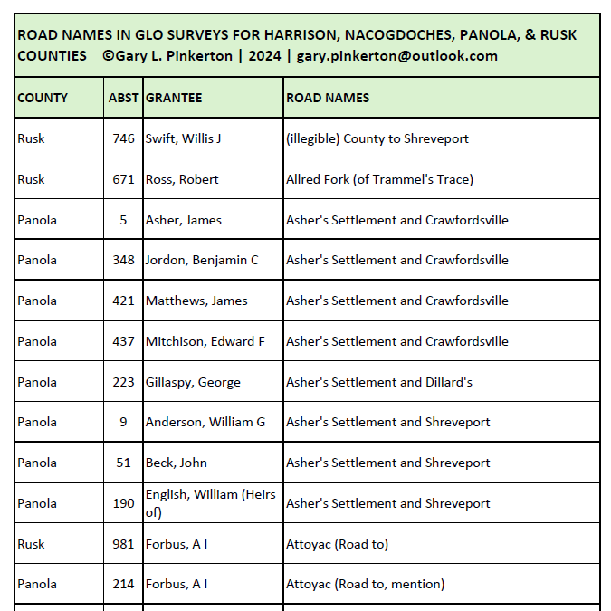
The two most significant fields include road names and places or features named in the surveyor notes. The roads come with a precise “survey call” with a measurement that allows one to convert it to Lat/Long and place that crossing at a specific point on a map. The place names include streams, land features, ferries, boundaries, homes, and land features created by animals. Here is an example of the kind of report we can produce for road names.
There have been several ongoing studies discussed at recent meetings of the East Texas Historical Association. Dr. Debbie Liles is compiling deed records research on property owners. The Lone Star Slavery Project led by Kyle Ainsworth of the East Texas Research Center is reading deeds from nine East Texas counties to document the slave society.
The challenges of the project that Dr. Tiller and I have begun involve all of the obstacles that come with gleaning and managing large amounts of data from multiple sources in a manner that allows standardized and simplified access to the data it holds. A certain amount of error in reading the handwriting and transcribing the notes is expected.
Using our spreadsheet we can examine the work schedule of individual surveyors and chain carriers by looking at the survey date, and know what they found important in each bounded survey. In our four East Texas counties of focus, there were 83 different surveyors and over 3,000 different names for chain carriers. We have found 251 different mentions of roads, 1,524 unique place names, and 103 unique trees and other vegetation. The way the data is maintained it can be exported to GIS systems like ArcGIS and the data represented on a map. The GLO did something similar in this mapping of Spanish and Mexican land grants. With the data we are collecting we can create similar maps using any of the additional data that we are documenting.
I’ll stop now with the description. If you have read this far you are either genuinely intrigued by this major research project, or you have humored me enough to read the whole thing (thank you, Mom). Jim and I are willing to share data and engage with others who may have an interest or be conducting research that can benefit from this work. For now, we are calling it the Texas Big Data Project, though I’m sure that will evolve.
Please email me if you would like to know more about this project or see other samples, including the spreadsheet. We can discuss how our craziness might help improve your sanity.